Alexandroupoli: “The largest burnt area on European territory for years,” says the Copernicus service
 ΧΡΟΝΟΣ ΑΝΑΓΝΩΣΗΣ 2 '

Πηγή Φωτογραφίας: αρχείου από μετεο- ΦΩΤΙΑ ΣΤΗ ΑΛΕΞΑΝΔΡΟΥΠΟΛΗ, ΚΟΝΤΑ ΣΤΟ ΧΩΡΙΟ ΑΥΡΑ (ΒΑΣΙΛΗΣ ΒΕΡΒΕΡΙΔΗΣ / ΜΟΤΙΟΝ ΤΕΑΜ)


The European Copernicus service is recording the extent of the destruction that has taken place in the last few days in the broader area of Alexandroupoli through the Sentinel satellite. Copernicus EU
According to what he claims in today’s post, the area that had burned until yesterday in Alexandroupoli (over 72,000 hectares ) is the largest recorded on European soil for several years.
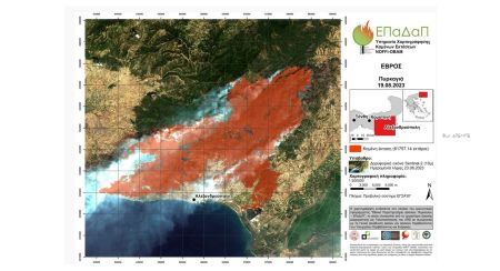
The Copernicus European service for the satellite recording of the burned areas and the damage caused by the great fire in Alexandroupoli was activated by the Planning and Emergency Management Directorate of the General Secretariat of Civil Protection last week following the General Secretary of Civil Protection order.
As stated in an announcement by the Ministry of Climate Crisis and Civil Protection, the purpose of the activation is the production of maps and data for areas of the Municipality of Alexandroupoli of the Regional Unit of Evros, which were affected by a fire that occurred on 19 August to assist the work of the agencies involved in dealing with emergencies and managing the consequences of the phenomenon.


Το σχόλιο σας