Severe weather alert for storm Athena: Upgraded weather warning – Expected to persist until Tuesday morning

Πηγή Φωτογραφίας: Eurokinissi (Αρχείου)//Severe weather alert for storm Athena: Upgraded weather warning – Expected to persist until Tuesday morning


The Hellenic National Meteorological Service (HNMS) warns of dangerous weather conditions, with Tuesday expected to be the most challenging day. The presence of a jet stream over the Mediterranean plays a key role in the development of this storm, and the affected regions are detailed in weather maps.
Storm “Athena” is forecast to impact Greece starting this evening and continue through Wednesday, with an upgraded Severe Weather Warning. A low-pressure system from the Central Mediterranean, moving eastward, is expected to bring intense rainfall, thunderstorms, frequent lightning, hail, and strong winds to various parts of the country, particularly the western, central, and northern mainland as well as the northern and eastern Aegean islands.
More Specifically:
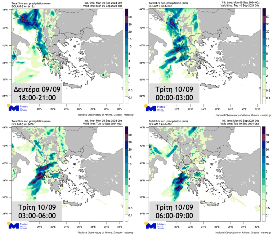
- Monday Evening (09/09/24) to Tuesday Morning (10/09/24): Heavy rain and thunderstorms are expected in the Ionian Islands, Epirus, Western Mainland, and Western Peloponnese. These conditions will intensify overnight.
- Tuesday Morning to Afternoon (10/09/24): Western Macedonia and Thessaly will experience significant weather events.
- Tuesday Late Morning to Wednesday (10/09/24 – 11/09/24): Central and Eastern Macedonia and the Sporades will face heavy rainfall.
- Tuesday Evening to Wednesday Afternoon (10/09/24 – 11/09/24): Thrace and the northern and eastern Aegean islands will be affected.
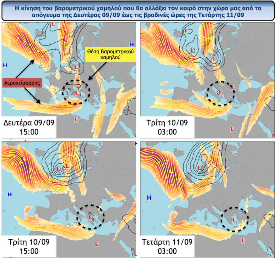
Role of the Jet Stream
The jet stream, an air current located around 10-11 km above ground level, is primarily moving from west to east. Its position over the Mediterranean has contributed to the formation of a low-pressure system over Italy, which will bring stormy weather to Greece starting from the west.
The storm will bring widespread rain and thunderstorms, with the most intense phenomena expected in northern Greece on Tuesday. Some areas may also experience hail.
According to the National Observatory of Athens, the storm ranks as a Category 3 (Significant) event on the Regional Precipitation Index.
Weather maps showing affected areas are available, detailing the expected heavy rainfall until Tuesday morning.
Finally, it is noted that according to the five-tier classification of rainfall episodes (Regional Precipitation Index), which is applied by the METEO unit of the National Observatory of Athens, the rainfall episode is classified in Category 3 (Significant).
Διαβάστε όλες τις τελευταίες Ειδήσεις από την Ελλάδα και τον Κόσμο


Το σχόλιο σας