Remote Sensing and agriculture:The first step to help our planet is to really understand what happening on it
Satellite data is an invaluable tool for climate-smart agriculture. It enables farmers to monitor weather conditions, assess climate patterns, manage water resources, mitigate risks from extreme events, and make informed decisions to optimize productivity and sustainability. Delivering high accuracy, broad coverage and valuable insights, is fundamental to decision-making for government policies, business strategies, science research investments and financial risk advisory.
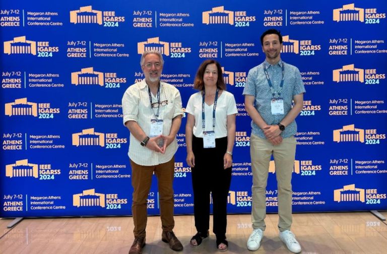
Dr. Nicos Spyropoulos is Director, Strategic Business Development EarthDaily Analytics. He has been involved in the commercial space industry for almost 30 years, working as executive at numerous satellite and space-balloon companies such as IIS-EOSAT Inc., Space Imaging (a Lockheed Martin, Raytheon and E-System Company), Definiens, Cosmotelco, KBI, 5CI, UrtheCast, Earthi, World View Enterprise and Space Perspective Inc. Dr. Spyropoulos received his BSc & MSc degrees in Land Reclamation, Hydraulics and Agr. Engineering from Athens University, MSc and Diploma in Remote Sensing from UCL and Imperial College, London and his PhD in Remote Sensing from the University of Athens. He has been Remote Sensing lecturer in postgraduate courses at University of Athens and Eurocourses at Joint Research Centre, European Commission, Ispra. His corporate functional experience together with international background and natural leadership enhance his strong negotiation skill and complex service selling capability.
Chris Rampersad is an experienced technical leader with over 20 years of experience working as a VP, Director, Technical Manager, Software Engineering Lead and Software Engineer. He possesses an excellent analytical aptitude and software engineering background, which he uses to help lead, develop software and provide technical guidance in the development of software systems. Chris has a solid track record of completing high-risk software projects on schedule by creating a clear vision and roadmap, and by leveraging effective software engineering practices including agile iterative development and risk management strategies. Currently, Chris Rampersad is Vice is President of Engineering at EarthDaily Analytics.
Cécile Tartarin pursued her education at L’Institut Agro Montpellier from 1996 to 1999, where she obtained a Master of Science degree in Agronomy and Crop Science. Cécile has a diverse work experience spanning over two companies. Cécile started her career at Union Invivo in 2001 as a Market Analyst and worked there until 2005. In 2008, she joined EarthDaily Agro as a Crop Analyst and later held various positions including Global Product Manager, Head of Product Management, and VP of Products & Solutions. Currently, she is serving as the VP of R&D at EarthDaily Agro.
Nicos Spiropoulos: Chris [Rampersad] and Cecilia [Tartarin] we are in Athens today for the IGARSS 2024 Symposium. Listening to the presentations this morning I realized that the climate change is here. It shows its facets with phenomena like wildfires, landslides and mega drought. So, I thought this is not climate change, this is climate crisis. So, I think we need to understand how our biosphere is behaving. And I was wondering, what is the best tool to use for this kind of global monitoring or a global change monitoring? Perhaps high cadence, scientific quality and robust satellites can be of great help and support. These could allow AI derived monitoring, predictive analytics or change detection alerting and thus help our planet or help us to understand its behavior. I don’t know, Chris, what do you think about this?
Chris Rampersad: Yes, those are great points. I think the first step to help our planet is to understand what’s happening and at a global scale, the only way is with satellites. We can’t really do it with aircraft and there are not enough people to monitor every square kilometer on the ground, so satellites are the key for us to understand how the whole planet changes on a dynamic basis. With our constellation of 10 satellites that are launching next year we will have the ability to understand that change. Both in terms of how water bodies are changing and also how the Earth’s landmass is changing. This will also give us information about natural disasters such as the risk associated with wildfires and that’s a crisis that’s happening around the world both here in Greece, but also where we’re from, in Vancouver. Satellites are the only way we can really understand the changes that are happening at a global scale and take action.
Nicos Spyropoulos: And Cecile I think that kind of technology from space, I believe that helped a lot with the food security issues. You know what’s your perception on this?
Cecile Tartarin: Yes. You mentioned the wildfire as an example of our climate crisis. This is only one example. The climate is also impacting a lot of the farmers and agriculture in general. So, we’re seeing more and more drought events developing around the Mediterranean basin and we see some extreme events as well affecting the crops, that we can monitor with the satellites. With satellite technology, we can do amazing things like identifying crop from space and then estimate the vegetation health. This is how we can anticipate crop yields at different scales, which enable the food supply chain to anticipate any kind of disruption. So, with such a system, anyone can have a global view every day of the situation of the agriculture on the planet.
Nicos Spyropoulos: We, as engineers and scientists, we need to massage the information and bring it down to earth in a more applicable way. I heard in the previous day that that we need to go outside the bubble of science, and we need to make this technology more acceptable by the farmers or the firefighters. So, what do you think about this? Is that possible by simplifying the technology and absorbing the scientific processing burden and generate products digestible ready for consumption and analysis?
Chris Rampersad: Yes, it is. Twenty 20 years ago, people would have used their eyes to look at satellite imagery, and nowadays there are just too many pixels. There are billions of pixels being captured every day. To interpret that, luckily, we have machine learning and different forms of AI. That’s really the only way you can interpret data at this scale and then start to understand how things are changing. At the end of the day, we’re not trying to see pretty pictures of a planet. We’re trying to understand the dynamic physical processes of what’s happening, whether it’s in agriculture or with wildfire risk. That’s more than a picture. That’s scientific information that you get from more colours than just what your eyes can see. It’s not just the red, green and blue. It’s near infrared. It’s long-wave thermal infrared. It’s the short wave-infrared. These are spectral signatures that are out there. We can’t see them with our eyes, but we can see them with satellite imagery and if we apply AI to that data, we can start extracting information and take action.
Cecile Tartarin: You have touched an interesting point as well about how to disseminate the research outputs down to real users. That’s why we are working as well on a platform which allows us to operationalize the results of the science and bring practical solutions to the farmers, and as well through the whole supply chain. By answering very specific business questions this it’s not only science but tools that anyone can use.
Nicos Spyropoulos: So, the future is bright for us, but also for the end users. People need this easy-to-get information, so they use to tackle their everyday problems.
Διαβάστε όλες τις τελευταίες Ειδήσεις από την Ελλάδα και τον Κόσμο


Το σχόλιο σας