“AI for Satellite Earth Observation: towards a Digital Earth Cortex”
Planet Earth has changed dramatically over the past few years: rising of the sea level, increasing levels of ocean acidification, drought, or frequent and extreme floods, or heat waves. Meanwhile, the world population growth and human activity amplify the effects of climate change. There is an increasing pressure on basic resources, such as fresh water or food, an accentuated stress on land and marine ecosystems, a dramatic explosion of environmental pollution, impacting health, and biodiversity. The question is how to monitor these changes, and more, how to understand their causes, predict, minimize or adapt to their effects? Will a digital Earth twin save the planet?
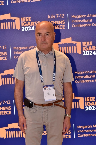
When it comes to Digital Twin Earth systems, hopes and fears abound in equal measure. In this interview Prof. Mihai Datcu has the answers that set the record straight on how this transformational technology is improving access to crucial information on the future of our planet.
Prof. Datcu participated the 44th annual “International Geoscience and Remote Sensing Symposium – IGARSS 2024” of the IEEE Geoscience and Remote Sensing Society, in Athens from 7-12 July, 2024.
Prof. Mihai Datcu is the author of more than 800 scientific publications, among them about 170 journal papers, and a book on number theory. He has served as a co-organizer of International Conferences and workshops, and as guest editor of special issue on big data or quantum machine learning of the IEEE and other journals. Since 1993, he has been a scientist with the German Aerospace Center (DLR), Oberpfaffenhofen. He is developing algorithms for model-based information retrieval from high complexity signals and methods for scene understanding from Very High-Resolution Synthetic Aperture Radar (SAR) and Interferometric SAR data. His research interests include Bayesian inference, information and complexity theory, artificial intelligence, computational imaging, quantum machine learning, and image information mining for applications in information retrieval and understanding high-resolution synthetic aperture radar (SAR) and optical observation. He is IEEE Fellow.
Prof. Datcu during the recent years, global warming and climate change are producing unexpected effects, in a negative manner. How do you use remote sensing to understand the changes the planet is going through?
Satellite remote sensing is playing a major role in this respect. Satellites are the only global, continuous Earth Observation (EO) data source. Hundreds of satellites capture land, ocean, polar areas, or atmosphere observation images. As an example, only the satellites of the European Copernicus programme that observe each point on the Earth’s surface have captured more than 30 million images in just a few years’ time. And needless to say, this EO data are now freely and openly accessible. However, satellite images are not mere photographs. These sensors are measuring the reflection of light, infrared or microwave radiation of Earth cover as vegetation, urban areas, lakes, or snow. Yet, these measurements are indirect. Remotely sensed observation of the relevant information in applications, as soil humidity, ocean temperature, or quantity and quality of crops and how these parameters are affected while the climate is changing, and adverse natural hazards are more often. The challenge is now how to extract this information from Big Data, a task much beyond the direct human capacity of analysis.
And how exactly do we deal with this challenge?
We have a method invented by Eratosthenes 2000 years ago. At that time, measuring the Earth’s circumference was impossible. But Eratosthenes used an indirect observation, the shadows cast by the sun on a vertical pole at different geographical locations, and by calculation he estimated -in an extremely precise manner- the Earth’s circumference. In EO we follow the same pattern: from indirect, remote satellite observation we extract the values of parameters of interest. Today, this is made possible by the availability of high-performance computing and the fantastic evolution of Artificial Intelligence (AI) as the epicentre of a new revolution boosted by Machine and Deep Learning (DL) methods, fostered by Big Data. Big Data is the process of collecting large volumes of data via EO satellite sensors, but also in-situ observations, people, or IoT, only to enumerate few modalities. AI is the convergence of theoretical methods and tools to transform Big Data in useful information and knowledge for making decisions, verify hypotheses, understand insights, or make predictions.
Could you be more specific as to how AI is involved in your field of expertise?
While satellite images are not photographs, and the objective of the EO data analysis is extraction of physical parameters and understanding of causalities, a new AI field is developing. AI has the role to browse of large global data sets and detect similar phenomena, as forest fires. Analyze the context, as relief -e.g. type of vegetation, temperature and humidity, water resources, presence of settlements or industrial sites- and derive the risk indicators but also the essential factors which could be used to avoid further disasters. Thus, the requirements of EO satellite data analysis are promoting new theoretical studies, emerging in a new very interdisciplinary branch of AI.
Modern AI, in synergy with satellite data, offers excellent prospects in learning the models of changes and effects of global warming, and thus, defend nature at global scale. Conventional methods typically have to be adapted for specific environments and regions. It is consequently very hard to implement harmonized, large-scale analysis with high spatial and temporal resolution and, at the same time, high performance and precision. The current AI based data driven approaches, are the major progress in support of EO data analysis for learning the models of global changes.
Prof. Datcu, you have done impressive work on synthesizing existing technological applications, culminating in crating Digital Twin Earth systems. Could this be the key to a more sustainable and resilient future for our planet?
The practical implementation of what I was describing earlier can be found in the new technology of Digital Twin Earth (DTE) systems. DTE are interactive systems, a digital media to observe, understand and model the effects of climate change via satellite EO and provide actionable information to local administration, industry, research and directly to citizens. DTE systems provide capabilities to visualize, monitor and forecast effects of climate change on natural phenomena and human activity on the planet in support of sustainable development for a better environment protection.
Climate models describe changes at a scale of thousands of kilometers and for long time periods e.g. for many decades. However, adaptation measures shall be applied at human activities scale, from 10m to 1km and periods from days to months. The DTE systems implement a virtual, dynamic models of the world, continuously updated, enabling simulations while providing more specific, localized and interactive information on climate change and how to deal with its impacts answering “what if” questions. For example, how crops’ production will evolve if drought is becoming excessive, or estimate forest damages as effect vegetation fires. The DTEs are also a tool to largely interact with people raising awareness and amplify the use of existing climate data and knowledge services, for the elaboration of local and specific adaptation. That is a step towards a citizen driven approach with an increased societal focus.
The coupled DTE systems support to promote a geographical diversity approach, involving various regions and communities, following a systemic approach converging several cross-modality themes and areas of innovation, implemented as an inclusive methodology to bring together public administration, private sector, civil society, and finally the citizens in person.
The source of the above interview is IGARSS 2024 Symposium
Διαβάστε όλες τις τελευταίες Ειδήσεις από την Ελλάδα και τον Κόσμο










Το σχόλιο σας