Today the coldest day of storm ‘Coral’ – Where it will snow – Rains coming from Monday
 ΧΡΟΝΟΣ ΑΝΑΓΝΩΣΗΣ 9 '

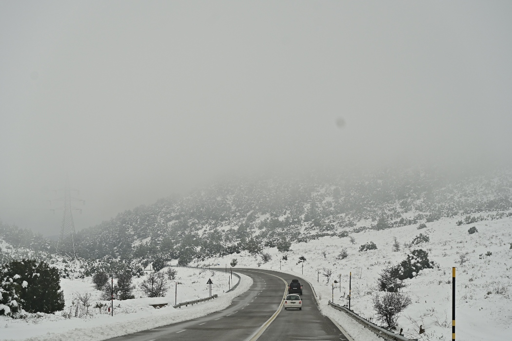
Πηγή Φωτογραφίας: ΧΙΟΝΙΑ ΣΤΗ ΛΕΣΒΟ (ΠΑΝΑΓΙΩΤΗΣ ΜΠΑΛΑΣΚΑΣ/ΕUROKINISSI)


The storm “Coral” continues to affect the country, and today is expected to be the coldest day. The wintery weather will persist until Monday, as low temperatures will be followed by rainfall, according to meteorologist Theodoros Kolydas.
As stated in a post by the director of the Hellenic National Meteorological Service (EMY), today “the regions affected will be Central Macedonia, Eastern Thessaly, Eastern Central Greece, Euboea, Sporades, Cyclades, and Crete. We will see rain or sleet and light snowfall in mountainous and semi-mountainous areas, as well as in lower-altitude regions of Eastern Thessaly, Eastern Central Greece, and Euboea. In Attica, however, no significant weather phenomena are expected. On Sunday, precipitation will weaken, and weather conditions will improve in most areas, except for the Ionian Islands and the southwestern Peloponnese, where local showers will occur. Temperatures will rise slightly, mainly in the west. On Monday, temperatures will climb a bit further, and rain is expected primarily in Western Greece.”
🥶🥶🥶ΔΙΑΤΗΡΗΣΗ ΤΟΥ ΚΥΜΑΤΟΣ ΨΥΧΟΥΣ #CORAL ✅Το έντονο κύμα ψύχους (με την ονομασία Coral) θα συνεχίσει να επηρεάζει μέχρι και τη Δευτέρα τη χώρα μας και την ευρύτερη περιοχή της νοτιοανατολικής Ευρώπης και της ανατολικής Μεσογείου. Παράλληλα θα επικρατούν τοπικά στο Αιγαίο…
— Theodoros Kolydas (@KolydasT) February 21, 2025
Emergency Weather Bulletin in Effect
The intense cold wave, named “Coral,” will continue to affect Greece, as well as the broader region of Southeastern Europe and the Eastern Mediterranean, through Monday. At the same time, strong northerly winds will prevail in the Aegean, reaching 7 Beaufort, and 8 Beaufort in the southern parts, with occasional snowfall, mostly light, in eastern mainland Greece, the Aegean islands, and Crete.
A. Detailed Forecast
TEMPERATURES
Saturday (22-02-25)
a) In Macedonia, Thrace, and the northern Aegean islands: from -5°C to 4-6°C. b) In Thessaly, Central and Eastern Central Greece, Eastern Peloponnese, and Euboea: from -3°C to 6-8°C.
Sunday (23-02-25)
a) In Macedonia, Thrace, and the northern Aegean islands: from -4°C to 5-7°C. b) In Thessaly, Central and Eastern Central Greece, Eastern Peloponnese, and Euboea: from -1°C to 9-11°C.
SNOWFALL
Saturday (22-02-25)
a) In Macedonia (mainly in central parts), Thessaly, Central and Eastern Central Greece (including Attica), Eastern Peloponnese, Euboea, and the northern and eastern Aegean islands, snowfall is expected in mountainous and semi-mountainous areas and, locally, at lower altitudes. b) In Crete, snowfall is expected in mountainous and semi-mountainous areas and possibly at lower altitudes as well. c) In the central and northern Cyclades, temporary snowfall is expected in the mountains.
Sunday (23-02-25)
a) In Macedonia (mainly central parts) and temporarily in Thessaly, Eastern Peloponnese, and Euboea, snowfall is expected in mountainous and semi-mountainous areas and, locally, at lower altitudes. b) In Crete, snowfall is expected in mountainous and semi-mountainous areas.
B. You can get a general outlook on the weather evolution on the HNMS website (www.oldportal.emy.gr), with forecasts available until Wednesday.
Today’s Weather
Increased cloud cover is expected over Central and Western Macedonia, Thessaly, Eastern Central Greece, Eastern Peloponnese, and Northern Crete, while the rest of the country will experience sunshine with occasional clouds. Scattered and temporary snowfall is expected mainly in Central and Western Macedonia, Thessaly, Eastern Central Greece, and the Peloponnese until noon, and later in the Pindus mountains. There is also a chance of isolated and brief rain showers or sleet in lower-altitude areas of Central Macedonia and Thessaly until noon and in Epirus later in the day.
Temperatures will range from:
- Western Macedonia: -8°C to 4°C
- Rest of Macedonia & Thrace: -6°C to 6°C
- Thessaly: -3°C to 7°C
- Epirus: -3°C to 11°C
- Western Central Greece: -2°C to 9°C
- Rest of Central Greece: -4°C to 7°C
- Peloponnese: -3°C to 11°C
- Ionian Islands: 4°C to 11°C
- Northern & Eastern Aegean Islands: -2°C to 4°C
- Cyclades: 2°C to 6°C
- Dodecanese: 4°C to 9°C
- Crete: 3°C to 10°C
Winds in the Aegean will blow from the north-northeast at 4-6 Beaufort, weakening slightly from midday. In the Ionian, winds will be easterly at 3-5 Beaufort, later shifting to variable at 2-4 Beaufort.
In Attica, clouds will persist until the afternoon. Winds will be northerly at 2-4 Beaufort, weakening slightly from midday. The temperature in central Athens will range from 2°C to 7°C.
In Thessaloniki, clouds will be present at times, with a chance of isolated, temporary, and light snowfall. Winds will be from the east-southeast at up to 3 Beaufort. The temperature in central Thessaloniki will range from 0°C to 4°C.
Sunday’s Weather (23-02-2025)
In Thrace, the Eastern Aegean Islands, and the Dodecanese, partly cloudy skies will be temporarily increased until midday. In the southern Ionian region (mainly around Zakynthos) and the western Peloponnese, increased cloud cover will bring local showers, with sporadic thunderstorms developing in coastal and marine areas from the afternoon. The rest of the country will see partly to mostly cloudy skies, with light local rain or sleet. Snow will fall in mountainous, semi-mountainous, and, locally, lower-altitude areas of Macedonia (mainly central), temporarily in Thessaly, Eastern Peloponnese, and Euboea, as well as in the mountainous and semi-mountainous areas of Crete.
Winds:
- Western Greece: East-southeast winds at 3-4 Beaufort, locally reaching 5 Beaufort in the south.
- Eastern Greece: North-northeast winds at 3-5 Beaufort, increasing to 5-6 Beaufort in the southern Aegean.
Temperature:
- Still very low.
- Northern Greece: -4°C to 5-7°C
- Eastern Mainland & Euboea: -1°C to 9-11°C
- Rest of the country: Up to 12-13°C
- Frost will occur in mainland areas.
The Weather on Monday, 24-02-2025
In Thrace, the Eastern Aegean islands, the Dodecanese, the Cyclades, and eastern Crete, there will be scattered clouds, which will increase from late afternoon. In the rest of the country, cloudy conditions are expected, with local rain or sleet in the east and scattered showers and thunderstorms in the west. Snow will fall in the mountainous and semi-mountainous areas of eastern mainland Greece.
Winds will blow southeast at 3 to 5 Beaufort in the west and up to 6 Beaufort locally in the south. In the east, they will blow from the north-northeast at 3 to 5 Beaufort, gradually shifting to east-southeast at the same intensity.
Temperatures will rise slightly in the west but will remain low in the east. Frost is expected in places in mainland Greece.
The Weather on Tuesday, 25-02-2025
In the Ionian, the western, central, and southern mainland, and gradually in the Cyclades, the northern and eastern Aegean islands, and the Dodecanese, rain and scattered thunderstorms are expected. In the rest of the country, increased cloud cover with local showers is forecast. Snow will fall in the mountainous areas of the mainland.
Winds will blow from the south at 3 to 5 Beaufort, temporarily shifting in the Ionian in the afternoon to west-northwest at the same intensity.
Temperatures will rise across the country, both in maximum and minimum values. Frost is expected in places in northern mainland Greece.
The Weather on Wednesday, 26-02-2025
In the Cyclades, the Eastern Aegean islands, and the Dodecanese, increased cloud cover with scattered showers and thunderstorms is expected, with gradual improvement in the north. In the rest of the country, cloudy conditions will prevail, temporarily increasing, with rain mainly in the west, central and southern mainland, the Sporades, Evia, and Crete. Light snowfall will occur in the mountainous areas of the mainland.
Winds in the west will blow from the south at 3 to 4 Beaufort. In the east, they will blow from the north-northeast at 4 to 5 Beaufort in the north, and from the west-northwest at 4 to 6 Beaufort in the south, weakening quickly.
Temperatures will remain relatively stable, with no significant changes.
Source: pagenews.gr
Διαβάστε όλες τις τελευταίες Ειδήσεις από την Ελλάδα και τον Κόσμο


Το σχόλιο σας