The Maritime Spatial Planning was announced
 ΧΡΟΝΟΣ ΑΝΑΓΝΩΣΗΣ 6 '


Greece is adopting, for the first time, a comprehensive and institutionalized Maritime Spatial Planning (MSP) with the issuance of the National Spatial Strategy for the Marine Space (NSSMS).
The official act establishing it was published today, following an initiative by the Ministry of Environment and Energy, in collaboration with the Ministry of Foreign Affairs and other competent ministries.
This marks a significant strategic milestone in the country’s spatial planning, as for the first time, the State defines and maps the uses and activities that can be developed across all marine zones, while simultaneously exercising its rights as provided by International Maritime Law and Directive 2014/89/EU.
The strategy provides a comprehensive response to the obligation that arose after the European Court of Justice condemned Greece this past February. It incorporates key elements regarding the Greek continental shelf, as well as Exclusive Economic Zone (EEZ) agreements with Italy and Egypt.
The adopted approach is holistic, integrating often conflicting parameters — social, economic, energy-related, and environmental — in order to serve objectives such as:
– climate resilience of the marine environment,
– sustainable tourism development,
– protection of cultural heritage and underwater antiquities,
– maritime safety and transport,
– exploitation of energy resources,
– aquaculture, and
– promotion of cross-border projects of common interest.
The strategy places special emphasis on co-shaping priorities for each region and on land-sea interactions, by providing Marine Spatial Frameworks for each area.
According to sources, the technical work from the Ministry of Environment had been completed for some time, while the issue had recently drawn significant attention at Maximos Mansion (the Prime Minister’s office), with ongoing coordination between Foreign Minister George Gerapetritis and Minister of Environment and Energy Stavros Papastavrou.
The activation of the NSSMS also gains additional geopolitical significance, as Turkey has repeatedly expressed objections to any Greek initiative regulating marine space in the Eastern Mediterranean.
The Strategy is expected to serve as a valuable tool for policy-making, diplomacy, and investment planning in Greece’s seas, substantiating the country’s sovereignty and maritime jurisdictions in a well-documented manner.
Q&A on Maritime Spatial Planning
- Why is the drafting, specification, and mapping of Maritime Spatial Planning (MSP) an important step?
It is the first time that the outer potential limits of the Greek continental shelf are recorded in an official EU regulatory document — meaning full effect of both the mainland and the islands in maritime zones.
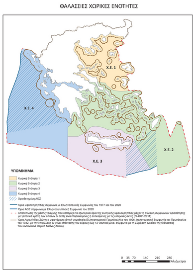
- So, what exactly does the map show?
The maritime areas shown on the map include the Greek-Italian EEZ delimitation agreements from 1977 and 2020, as well as the Greek-Egyptian agreement of 2020. These align with the boundaries defined in Law 4001/2011.
For areas not yet delimited, the map shows the median line, which defines the outer boundary of the Greek continental shelf, pending the conclusion of delimitation agreements with neighboring states whose coasts are adjacent or opposite those of Greece.
- Does this mean the map outlines Greece’s full EEZ (in the Ionian, the Aegean, and the Eastern Mediterranean)?
The delimitation of maritime zones is a different process from Maritime Spatial Planning, which involves how national authorities analyze and organize human activities in these maritime areas to achieve ecological, economic, and social goals.
Therefore, the map reflecting Greece’s MSP does not constitute EEZ delimitation.
- Does it reflect the extension of Greece’s territorial waters to 12 nautical miles (in the Aegean and Eastern Mediterranean)?
The extension of territorial waters up to 12 nautical miles is a sovereign right of Greece under the UN Convention on the Law of the Sea (UNCLOS). It is a right that Greece reserves the option to exercise when and how it deems it appropriate in line with national interest and international law.
- How is the MSP linked to sovereignty and the exercise of sovereign rights?
MSP and its mapping reflect the planning of activities across all maritime zones of the country — not the exercise of sovereign rights.
Sovereignty is not subject to planning. It preexists and is not influenced by the planning process.
- Why is the government presenting the MSP now?
The government is closing long-standing issues of the past. It defends national interests substantively and effectively, not through superficial communication tactics.
- Could this MSP trigger a reaction from Turkey? Does this mean you’re abandoning Greek-Turkish dialogue?
Resolving past issues doesn’t mean Greece is abandoning dialogue. Disagreeing doesn’t mean not talking. Talking doesn’t mean making concessions, and this is shown in practice. Greece wants a positive climate in relations with Turkey and has consistently supported dialogue based on international law and good neighborly relations.
Moreover, MSP is a fundamental obligation of Greece toward the EU, stemming from specific European directives, and is part of broader goals like the European Green Deal and the EU Maritime Security Strategy (EUMSS).
Source: pagenews.gr
Διαβάστε όλες τις τελευταίες Ειδήσεις από την Ελλάδα και τον Κόσμο


Το σχόλιο σας